
Hydrology, drainage design, and water quality analysis, built for engineers who design every day.
Storm Master handles TR-55 and TR-20 hydrology, pond routing, culvert and inlet sizing, and water quality in one licensed workspace, with reporting that's actually ready to submit. If you work in Civil 3D, it also restores your original part families and sizes automatically after a LandXML round-trip.
Every drainage workflow hits the same three walls.
Different tool, same friction: cost, formatting, or lost data.
“We modeled the small system to stay in a cheaper license tier.”
Element-count license tiers mean costs climb as a network grows, on top of a subscription that renews every year whether the project is still active or not.
“Our reports need a rewrite before they leave the office.”
The analysis works, but the output is dated and hard to customize for client-ready deliverables.
“Every LandXML re-import means reassigning parts by hand.”
Civil 3D has no built-in way to preserve part family and size identity through a round-trip. So someone ends up fixing it by hand, every time.
Three workflows solved.
Stop paying for network size.
A one-time, per-seat license instead of a subscription that scales with element count and renews every year.
Reports that don't need rework.
Modern, customizable HTML reporting for culvert runs, structure diagnostics, and project summaries.
Migrate without losing data.
Built-in part-migration tools carry your part families and structure styles through the round-trip, automatically.
Everything a drainage design needs, one license.
Hydrology
TR-55 / TR-20 methods, pond routing, HGL/tailwater coupling.
Automatic weighted Cs / CN
Composite runoff coefficients and curve numbers computed automatically from your sub-area breakdown and USDA SSURGO soil data for the site, pinned to the published ASCE and TR-55 tables across 45 surface materials.
Culvert & inlet sizing
Automated culvert runs and open-channel structure auto-sizing.
Auto-detect structure bypass
Storm Master detects when a structure is over capacity and routes the overflow to the next downstream structure automatically, no manual bypass assignment.
Ditches
Trapezoidal channel design with depth, velocity, and freeboard checked against the tributary hydrograph automatically.
Water quality / BMP
Runoff coefficient tables, BMP credit sizing, pollutant loading.
Custom reporting
Editable report narratives with fill-in placeholders for jurisdiction, design requirements, and site conditions, not just data tables.
HydraFlow import
Bring in existing HydraFlow STM projects directly.
Civil 3D part migration
Restores original part families & sizes after round-trip. Ships with multiple DOT structure templates built in.
Also included
- Report revisions, with version history tracked across submittal rounds
- Draggable labels: drag any label and a leader arrow draws itself, flipping to read outward, with positions held at every zoom
- Batch edit for structures and pipes, so shared properties update across many at once instead of one at a time
- QA design checks flag cover, velocity, slope, gutter spread, and HGL-vs-rim issues in one pass
- Channel lining sized to HEC-15: riprap D50, shear stress, and lining pass/fail for ditches and channels
- Quantity takeoff: pipe length by size and material, structure counts, broken out by run
Stop measuring impervious area by hand.
Point Storm Master at your CAD drawing and it finds the hatched surfaces, groups them by layer, and turns them into sub-areas with the weighted runoff coefficient already computed. No exploded polylines, no area takeoff, no transcription. Works on existing conditions too: classify an aerial photograph into woods, lawn, water, pavement, and roofs, review the result on screen, and create sub-areas from it.
From CAD, in one pass
Solid and pattern hatches are found across every visible layer, grouped, and sorted largest first. Regions that cross a drainage-area boundary are clipped to it, so a road hatch spanning three areas contributes its correct slice to each. Landscape islands inside a parking lot are subtracted automatically. Layers matching AIA/NCS naming are pre-assigned, and layers that are never a proposed surface can be removed and stay removed.
From an aerial, with you in the loop
Train nine cover classes by clicking a few sample points, then classify every pixel inside your boundary. The result is drawn over the photograph at half opacity so you compare it against what you can see before accepting anything.
The actual workspace, not a demo.
These are live screenshots pulled straight from a real Storm Master project file.
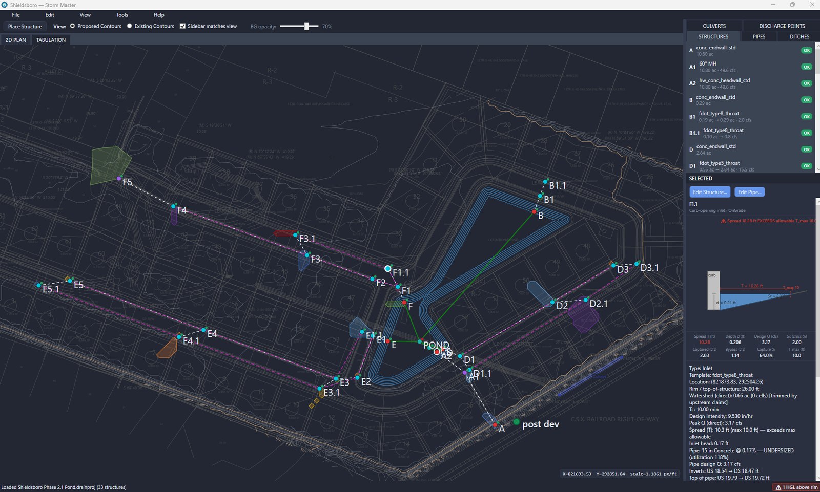
Real-time capacity checks, not a report you find out about later
Every structure and pipe shows status inline as you design. This inlet is flagging spread that exceeds the 10 ft allowable and an undersized downstream pipe running at 118% utilization, with full spread, capture, and bypass calculations right there in the side panel.
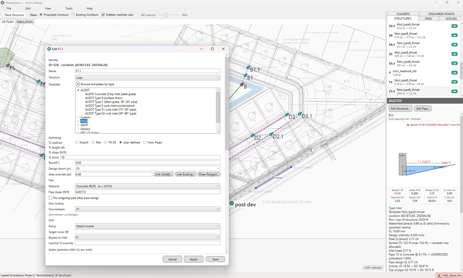
A real multi-jurisdiction template library
Browse ALDOT, FDOT, GDOT, and generic structure templates by type, then configure time-of-concentration method (Kirpich, FAA, TR-55), pipe material, and HEC-22 gutter geometry, all without leaving the dialog you're already in.
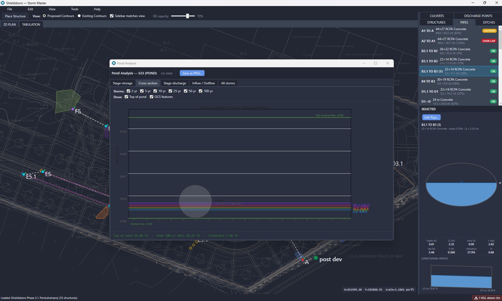
Full pond analysis across every design storm at once
Stage-storage, stage-discharge, cross-section, and inflow/outflow views for the 2-yr through 100-yr storms side by side, with top-of-pond, peak WSEL, and freeboard reported automatically. Export straight to PNG when you're ready for your submittal.
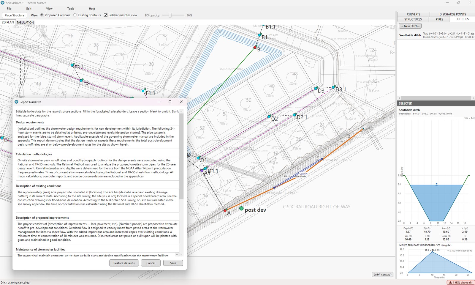
Ditch design and report narratives that are actually yours to edit
This trapezoidal ditch is sized against an implied tributary hydrograph, with depth, velocity, and freeboard checked automatically. The Report Narrative dialog behind it holds your firm's boilerplate as editable prose, with bracketed placeholders for jurisdiction, design requirements, and site conditions, restorable to defaults any time.
If you work in Civil 3D, here's how the round-trip works.
Five steps, one continuous run: from Civil 3D, through Storm Master, and back with parts intact. Not using Civil 3D? Skip ahead, Storm Master runs standalone too.
Export from Civil 3D
One click drives the native STM / LandXML export.
Import to Storm Master
Pipe network, parts, and structures load automatically.
Design & analyze
Hydrology, pond routing, water quality, culvert sizing.
Generate reports
Client-ready HTML reports, no external report writer.
Restore to Civil 3D
Original part families & sizes come back automatically.
Not just cheaper. Actually different.
| Bentley (SewerGEMS / CivilStorm) |
HydroCAD | Autodesk InfoDrainage | PCSWMM / EPA SWMM |
Storm Master | |
|---|---|---|---|---|---|
| Licensing | Tiered / subscription | One-time | Subscription | Commercial, per seat | One-time / seat |
| Customizable reporting | Limited | Rigid | Yes | Technical only | Yes |
| Water quality / BMP built in | Add-on | No | Partial | Manual setup | Yes |
| Civil 3D part round-trip | No | No | No | No | Yes |
Storm Master is the only option that pairs one-time pricing with a native Civil 3D part round-trip, and that holds across every major hydraulic modeling tool on the market.
Every method, side by side.
This is the same comparison our own team uses internally: hydrology methods, storm sewer design, ponds, advanced routing, water quality, CAD integration, and licensing, across eight tools.
Stormwater & Hydrology Software
Feature Comparison Matrix
Storm Master measured against the tools civil engineers actually reach for, from full hydraulic suites to the free reference engine and the niche water-quality and erosion tools.
| Capability | Storm MasterDrainageEngine | AutodeskInfoDrainage | BentleyOpenFlows Storm | HydroCAD | EPA SWMM | BMPTRAINS | NA GreenECMDS |
|---|---|---|---|---|---|---|---|
| Hydrology & runoff | |||||||
| Rational method (Q = C·i·A) | ● | ● | ● | ● | – | – | – |
| SCS / NRCS TR-55 curve number | ● | ● | ● | ● | ◐ | ◐ | – |
| TR-20 / full unit-hydrograph routing | ● | ● | ● | ● | ● | – | – |
| SBUH hydrograph | ● | ◐ | ◐ | ● | – | – | – |
| Time of concentration (Kirpich/FAA/TR-55) | ● | ● | ● | ● | ◐ | – | – |
| Watershed delineation from terrain | ● | ◐ | ◐ | – | – | – | – |
| Automatic weighted Cs / CN | ● | ● | ● | ● | ◐ | ◐ | – |
| Storm sewer & inlets | |||||||
| Pipe network design / auto-sizing | ● | ● | ● | ◐ | ◐ | – | – |
| Inlet capture & gutter spread (HEC-22) | ● | ● | ● | – | ◐ | – | – |
| Automatic bypass routing | ● | ◐ | ◐ | – | ◐ | – | – |
| HGL / EGL analysis | ● | ● | ● | ◐ | ● | – | – |
| Ponds & outlet structures | |||||||
| Detention / retention routing | ● | ● | ● | ● | ● | ◐ | – |
| Outlet structures (weir / orifice / culvert) | ● | ● | ● | ● | ● | ◐ | – |
| Multi-stage / multi-storm pond analysis | ● | ● | ● | ● | ● | ◐ | – |
| Exfiltration / infiltration | ● | ● | ● | ◐ | ● | ● | – |
| Advanced routing & flood | |||||||
| Dynamic unsteady (St. Venant / SWMM) | – | ● | ● | – | ● | – | – |
| 1D / 2D overland flood modeling | – | ● | ● | – | ◐ | – | – |
| Continuous / long-term simulation | – | ● | ● | ◐ | ● | ● | – |
| Channels, culverts & erosion | |||||||
| Open-channel / ditch design | ● | ● | ● | ◐ | ● | ◐ | ◐ |
| Culvert analysis | ● | ● | ● | ● | ◐ | – | – |
| Riprap / outlet scour (HEC-14) | ● | ◐ | ◐ | – | – | – | ● |
| Erosion control / RECP / channel lining | ● | – | – | – | – | – | ● |
| Water quality & BMP | |||||||
| Pollutant loading (TN / TP / TSS) | ● | ◐ | ◐ | ◐ | ● | ● | – |
| WQ treatment-volume / BMP sizing | ● | ◐ | ◐ | ◐ | ◐ | ● | – |
| BMP / LID library & treatment train | ● | ● | ◐ | ◐ | ● | ● | – |
| Data & CAD integration | |||||||
| Civil 3D / CAD integration | ● | ● | ◐ | ◐ | – | – | – |
| Automatic sub-area extraction (CAD hatches / aerial) | ● | – | – | – | – | – | – |
| LandXML / TIN surface import | ● | ● | ◐ | ◐ | – | – | – |
| Aerial imagery / basemaps | ● | ● | ● | – | ◐ | – | – |
| NOAA Atlas 14 rainfall (native) | ● | ◐ | ◐ | ● | ◐ | ◐ | – |
| USDA SSURGO soils (native lookup) | ● | – | – | ◐ | – | – | ◐ |
| Output & platform | |||||||
| Permit-ready report generation | ● | ● | ● | ● | ◐ | ◐ | ◐ |
| Windows desktop application | ● | ● | ● | ● | ● | ● | ◐ |
Simple, one-time pricing.
- No recurring, size-tiered subscription fees
- No surprise renewal cost as your models grow
- Includes hydrology, water quality, reporting, and Civil 3D migration tools
- Optional support / upgrade plan for future releases
- Bulk pricing available for 10+ seats, just ask for a quote
- Upgrade credit for existing customers: when major new capabilities ship (dynamic unsteady routing, 1D/2D overland flood modeling, long-term simulation), you'll only pay the difference, never full price again
Checked against the standards you already cite.
Storm Master's benchmarks are pinned to published methods, not just internal test cases. The validation manual documents worked examples with expected values, so a reviewing agency can check the method instead of taking it on faith.
Proven with real firms, on real projects.
Storm Master was built and refined with real engineering firms, running real pipe networks and real reporting requirements. What you get today has already been stress-tested by working engineers.
- Tested against actual drainage projects
- Direct feedback loop with the product team
- Named customer references available on request
Ready to see it on your own project?
Request a demo and we'll run Storm Master against a real pipe network from your firm.